%20--%3e%3csvg%20width='150'%20height='150'%20viewBox='0%200%2039.6875%2039.6875'%20version='1.1'%20id='svg18535'%20xmlns='http://www.w3.org/2000/svg'%20xmlns:svg='http://www.w3.org/2000/svg'%3e%3cdefs%20id='defs18532'%20/%3e%3cg%20id='layer1'%3e%3cg%20id='g18458'%20transform='matrix(0.2601049,0,0,0.2601049,-133.21064,44.068186)'%3e%3cpath%20style='fill:%231974d0;fill-opacity:1;stroke:none;stroke-width:0;stroke-linecap:butt;stroke-linejoin:miter;stroke-miterlimit:4;stroke-dasharray:none;stroke-opacity:1'%20d='m%20553.44758,-106.47121%2026.32912,0.0141%208.19744,3.18347%209.55323,-3.09208%2026.42944,-0.0134%20c%206.44522,0%2010.27714,6.29328%2011.48356,10.168785%201.24522,3.875123%2013.57153,45.970596%2013.57153,45.970596%201.83227,9.554001%20-3.54694,11.325798%20-8.96726,11.624065%20l%20-101.39551,9.56e-4%20c%20-6.27972,0%20-11.77948,-6.845557%20-11.20795,-13.20433%20l%2013.46938,-45.632927%20c%203.21727,-6.782045%207.07249,-8.541525%2012.53702,-9.019215%20z'%20id='path1166-1'%20/%3e%3cpath%20style='fill:%23f3b009;stroke-width:0.264583'%20d='m%20586.34795,-38.648532%20c%200,0%202.81261,-3.426062%206.15959,-7.019362%203.34698,-3.59329%206.08541,-6.69962%206.08541,-6.90295%200,-0.68347%20-38.15594,-22.925019%20-38.76722,-22.597869%20-0.28763,0.15394%20-7.57751,5.2138%20-16.19974,11.24415%20-12.08795,8.454259%20-16.18481,12.105485%20-16.18481,12.105485%20l%204.13292,-14.024518%2022.29733,-14.617855%20-15.44976,-8.788046%202.26814,-7.371511%2032.11381,19.067964%20c%200,0%2031.62,18.520831%2031.80846,18.520831%200.18847,0%2013.96282,-14.57156%2013.96282,-14.57156%20l%2018.13482,-18.426924%202.54732,8.590262%20-21.60573,23.273471%20-20.29127,21.525169%20z'%20id='path392-8-6'%20/%3e%3cpath%20style='fill:%23f24336;stroke-width:0.264583'%20d='m%20586.241,-72.975998%20c%20-2.72831,-0.8947%20-1.69314,0.38818%20-17.37795,-21.53642%20-9.55338,-13.353932%20-11.36791,-18.220992%20-10.16096,-27.254322%204.3309,-32.41418%2050.06177,-35.28469%2058.13945,-3.6494%202.92224,11.44459%201.06072,16.37549%20-13.8753,36.753672%20-12.1225,16.5395%20-12.64101,17.02581%20-16.72524,15.68647%20z%20m%204.88551,-32.717412%20c%208.91524,-2.32213%2012.54936,-13.01834%206.82556,-20.08952%20-7.22469,-8.92537%20-21.4176,-4.53544%20-22.4506,6.94409%20-0.74939,8.32764%207.4944,15.26319%2015.62504,13.14543%20z'%20id='path390-1-8'%20/%3e%3cpath%20style='fill:%23679e37;stroke-width:0.264583'%20d='m%20531.5741,-65.843596%206.84757,-23.405901%2015.44976,8.788046%20z'%20id='path386-1-6'%20/%3e%3cpath%20d='m%20597.36004,-38.641795%20c%200,0%202.35436,-2.912487%205.22837,-5.991287%2026.96915,-28.89078%2036.6668,-38.80563%2036.6668,-38.80563%20l%209.7334,33.170796%20c%200.35179,1.191679%203.03329,11.687471%20-9.53459,11.673365%20z'%20style='fill:%23679e37;stroke-width:0.0700042'%20id='path6471-7-6'%20/%3e%3c/g%3e%3c/g%3e%3c/svg%3e)
ASdev Maps
High Quality Maps
for those who wants:
- Privacy
- Freedom
- Tools
- NO advertisement
Privacy Features
- Free from ADS
- Free from Analytics
- NO LOG policy
- NO limits (ndèghe piàn)
- Available only to close friends
Map Features
- Full Planet Data
- Contour Lines
- Natural Earth
- Actionable layers
- POI
- Route Planner
System Capabilities
- Reverse geocoding
- Place search
- Address search
- Overpass API
- Routing
Data Credits
This project would not have been possibile without those important Open Data providers
OpenStreetMap

OpenStreetMap® is open data, licensed under the Open Data Commons Open Database License (ODbL) by the OpenStreetMap Foundation (OSMF).
ViewFinderPanoramas
Jonathan de Ferranti BA
ViewFinderPanoramas's hard work collecting Digital Elevation Models of the entire world, with precise accuracy (less then 30 meters in Europe!) was critical for this project.
Data from the website was used to:
- Compile contour lines
- Elaborate hills shading
- Create a reliefs layer
Data MUST be used for research and private use only.
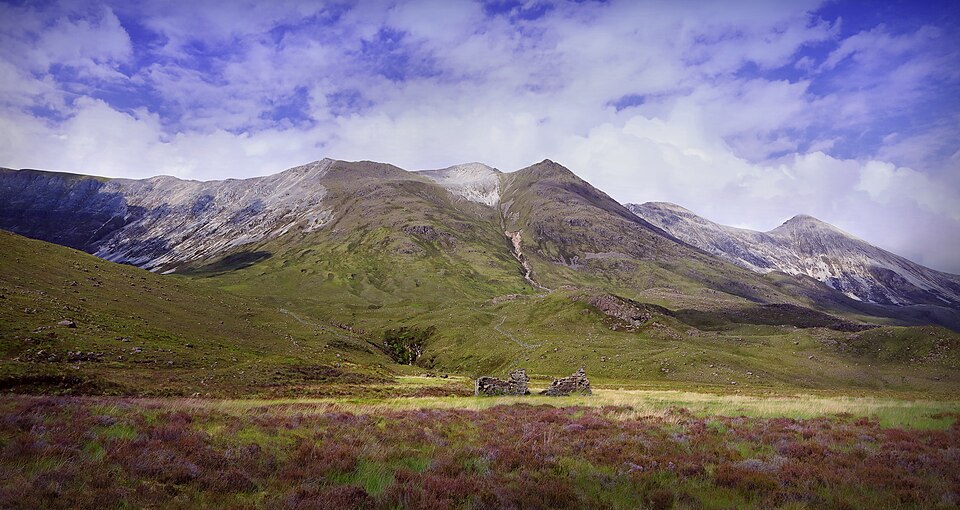
Since there is no logo on the website, I choosed a wikimedia photo picturing somewhere on the road to Gairloch taken by Charlie From Bristol
Natural Earth Data

Natural Earth Data datasets was used to compile the base layer of the map
Natural Earth is a public domain map dataset available at 1:10m, 1:50m, and 1:110 million scales. Featuring tightly integrated vector and raster data, with Natural Earth you can make a variety of visually pleasing, well-crafted maps with cartography or GIS software. Natural Earth was built through a collaboration of many volunteers and is supported by NACIS (North American Cartographic Information Society).
Natural Earth Data is free for use in any type of project: take a look at their Term of use
Software Credits
This project would not have been possibile without those important Open Source software

GraphHopper

Graphhopper manages routing and other navigation features like isochrone and route optimization.
Nominatim

Le tecnologie di reverse geocoding e ricerca di elementi sono state sviluppate da Nominatim